Interpretation of seismic data
Seismic interpretation is the process by which seismic data is converted into a geological understanding of the subsurface.
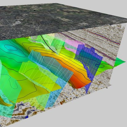
Seismic interpretation is the process by which seismic data is converted into a geological understanding of the subsurface.
The interpretation of seismic data forms the basis for decision-making in geothermal energy, mineral exploration, underground storage and infrastructure projects. The results enable geological structures, deposits, storage formations and potential underground risks to be precisely identified and assessed.
Silke Bißmann
Seismic Exploration Operations
+49 160 888 1765
Geological feasibility depends largely on the quality of the interpretation. Whilst seismic data acquisition provides the foundation, it is only through expert analysis that the full potential of the data is realised.
We combine geological and geophysical expertise with modern digital tools to convert complex seismic datasets into consistent structural models. In doing so, we combine many years of experience with innovative methods of digital subsurface modelling.
The resulting models support projects throughout their entire life cycle, from initial exploration through feasibility studies and the detailed planning and assessment of subsurface utilisation, right through to long-term operation and the associated adaptation, expansion and risk minimisation.
The interpretation of seismic data provides crucial information for a range of applications:
To ensure high model quality and maximum interpretative value, we rely on integrated interpretation workflows and established software solutions such as PETREL™ from Schlumberger. The key steps in the process include:
We identify impedance contrasts and map stratigraphic and tectonic structures in the subsurface.
Reflectors are tracked across the entire dataset in order to define contiguous horizons and identify discontinuities such as disturbances or eroded surfaces.
Well data, geological models and other geophysical data are integrated to improve the reliability of interpretations and reduce uncertainties.
Using calibrated velocity models, we convert results from the time domain into precise spatial depth models.
Based on this interpretation, we create static 3D subsurface models to serve as the basis for further simulations and assessments.
Seismic interpretation involves analysing seismic data to identify and evaluate geological structures, horizons, faults and deposits in the subsurface.
It provides the basis for well-informed decisions in exploration, geothermal, storage and infrastructure projects and reduces geological uncertainties.
In addition to seismic data, borehole information, geological maps, velocity models and other geophysical data are frequently integrated.
A 3D geomodel is a digital representation of the subsurface that spatially depicts geological structures and properties and serves as a basis for simulations and assessments.
Typical areas of application include geothermal energy, mineral and energy exploration, underground storage, hydrogeology, and infrastructure and construction projects.