Geomonitoring
Accurate measurement data for confident decision-making
Request consulting on Geomonitoring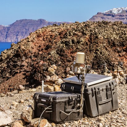
Accurate measurement data for confident decision-making
Request consulting on GeomonitoringGeomonitoring provides transparency regarding ground movements, structural deformations, vibrations and the behaviour of the subsoil, structures and infrastructure. Through the continuous collection, analysis and interpretation of relevant measurement data, changes can be detected at an early stage, risks assessed and well-informed decisions made.
DMT develops and operates bespoke monitoring solutions for the mining, construction and infrastructure sectors, as well as for energy supply. In doing so, we combine expertise in geotechnical engineering, geodesy, geophysics, seismology and digitalisation within a holistic monitoring concept.
Using state-of-the-art sensor technology, automated measurement systems and the DMT SAFEGUARD digital platform, we create the data foundation for planning, construction, operation, risk management and the protection of people, structures and facilities.
Dr Karsten Zimmermann
Head of Monitoring and Data Engineering
+49 151 543 588 46
Would you like to set up a secure database for your project? I look forward to hearing from you.
DMT supports projects from the consultation and measurement planning stages, through the installation and operation of monitoring solutions, to the technical evaluation of the results.
This results in integrated solutions that enhance technical safety, reduce risks and support decision-making processes.
In the mining industry, geomonitoring helps to monitor ground movements, surface areas, spoil heaps, embankments and other mining-related impacts.
In civil engineering, geomonitoring provides reliable information on the behaviour of structures and the subsoil during the construction phase and whilst in operation.
Continuous measurements provide transparency and support safe planning, construction and operational processes.
DMT monitors vibrations and seismic events using state-of-the-art measurement systems and automated analysis methods.
DMT is authorised as a measuring station under Section 29b of the Federal Immission Control Act (BImSchG).
Existing sensors and data sources can be integrated into existing monitoring systems, regardless of the manufacturer.
DMT SAFEGUARD is the digital monitoring platform for the centralised collection, management, analysis and visualisation of monitoring data.
The platform brings together geodetic, geotechnical, geophysical, hydrological and other sensor data in a single centralised application.
DMT combines more than 280 years of engineering experience with modern digitalisation and interdisciplinary expertise. As an independent company within the TÜV NORD GROUP, DMT develops bespoke monitoring solutions for complex projects in the mining, infrastructure, energy and industrial sectors.
Our experts will support you every step of the way, from planning the measurements and implementing the monitoring solution through to the technical interpretation of the results.
Contact our experts and work with us to develop a bespoke geomonitoring concept for your project.
Geomonitoring involves the recording, analysis and assessment of ground movements, structural deformations, vibrations, and geotechnical and hydrological parameters for the early detection of risks.
Automated systems continuously record measurement data, visualise trends in real time and trigger alarms when defined thresholds are exceeded.
Structural monitoring is used in particular for buildings, bridges, tunnels, excavation pits and critical infrastructure to reliably monitor deformations and changes.
DMT uses GNSS systems, total stations, laser scanners, radar interferometry, geotechnical sensors, and seismic and hydrological measurement systems.
Yes. DMT is manufacturer-independent and integrates existing sensors, measuring instruments and data sources into a central monitoring platform.